
Walk a Neenah Street Directory
A sound address search moves from the street to the parcel, then from the parcel to records that name a person or entity in a defined role. Neenah maintains the current municipal assessment record for city parcels. Winnebago County supplies a second view through its assessor search and Parcel Viewer. Neither one is a list of occupants. They identify an owner, mailing recipient, tax key, legal description, and other property facts. Those details make the next searches more exact.
The order matters. A postal city can say Neenah even when the parcel lies in an adjacent town, and a post-office box can differ from the situs, the physical place being assessed. Save the source date at each stop.
- Enter the complete address in the City of Neenah property inquiry. Copy the tax key, situs, mailing address, legal description, and effective date.
- Test the address or tax key in the county assessor and Parcel Viewer. Confirm the municipality and inspect nearby parcels.
- Use MyVote only for your own voter record, or obtain lawful public voter data through the state route. Do not treat a voter match as ownership.
- Carry the legal description or document number to the Register of Deeds. Search party names and the legal description because either index can contain errors.
- For an older household, consult the library's street index, then check a newspaper, census, deed, or map before drawing a conclusion.
The result is an evidence chain, not one merged profile. That keeps street-by-street research useful for genealogy, estate work, and property study without overstating a public record.
Search Neenah Property Fields
The Winnebago County Assessor Parcel Inquiry has three distinct search paths. It reports current and historical data through 2003, but current ownership for property inside Neenah should be checked through the municipal source. A search can begin with an address even when an owner's name is unknown.
| Search route | Fields shown | Best use |
|---|---|---|
| PIN | Pin 1, Pin 2, Pin 3, Pin 4 | Match an exact parcel across systems |
| Location | Number, direction, street, suffix | Find a parcel by street address |
| Owner | Last name, first name | Test a known ownership name |
Open the county assessor search before reviewing its captured fields.
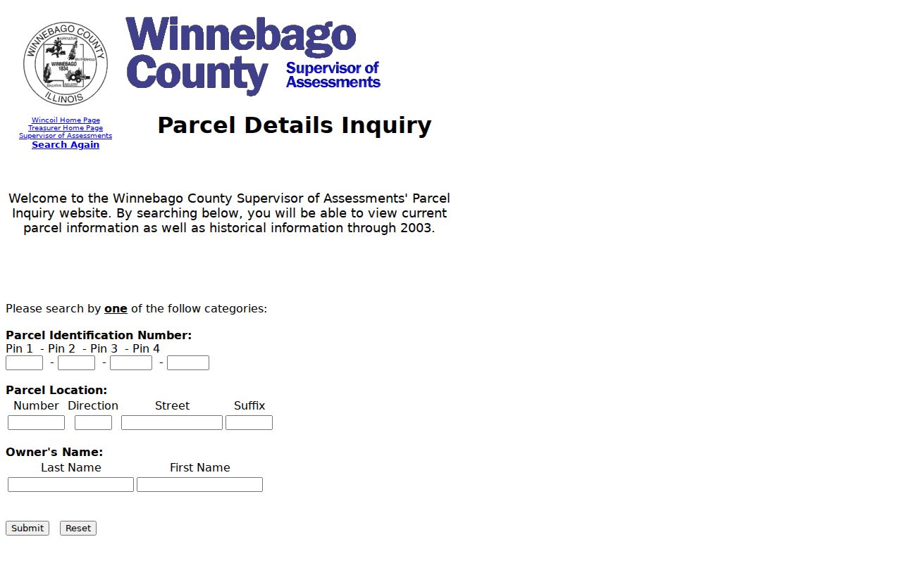
The form places all three routes side by side. It does not offer a verified ZIP filter, so use its street fields or PIN.
Inside a Neenah Address Record
The City of Neenah Property Records search is the key current source for a parcel inside the city. A sample record effective January 1, 2026 includes the tax key, situs, mailing address, land and improvement assessments, zoning, utilities, legal description, sale data, and building permits. These are separate fields with separate meanings.
Review the city's sample property record to see that structure.
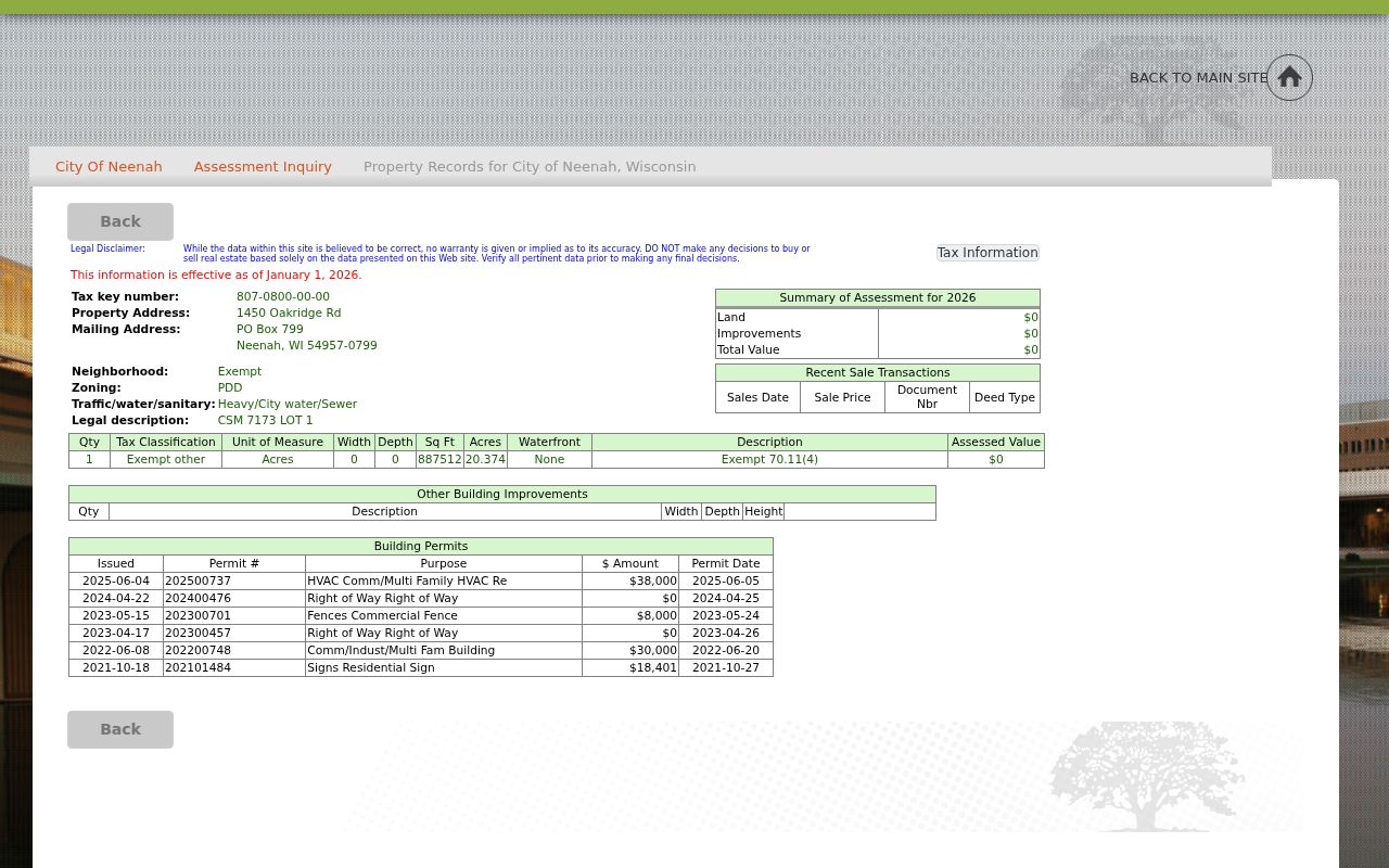
The sample links an Oakridge Road situs to a tax key, a different mailing destination, a short legal description, and dated sale and permit entries. It does not identify every person living there.
- Parcel
- A mapped unit of land identified by a PIN or local tax key.
- Situs address
- The physical property location, which can differ from its mailing address.
- Plat
- A recorded map that divides land into lots, blocks, streets, or other bounds.
- Criss-cross directory
- A directory arranged by street and house number instead of only by surname.
Map Neenah Streets by Parcel
The Winnebago County Parcel Viewer accepts a PIN, owner, address, certified survey map number, subdivision, or municipality. Its profile may show ownership, mailing address, short legal description, assessed value, school district, zoning, tax links, and parcel lineage. It helps a user move along a street and check whether nearby house numbers belong to separate parcels.
The map is still an index layer. A line on screen does not replace a recorded deed or survey. For a split lot, condominium, or old rural tract, a certified survey map, often shortened to CSM, may find the correct parcel when the street number does not.
Inspect the county parcel layer field list shown in the captured view.
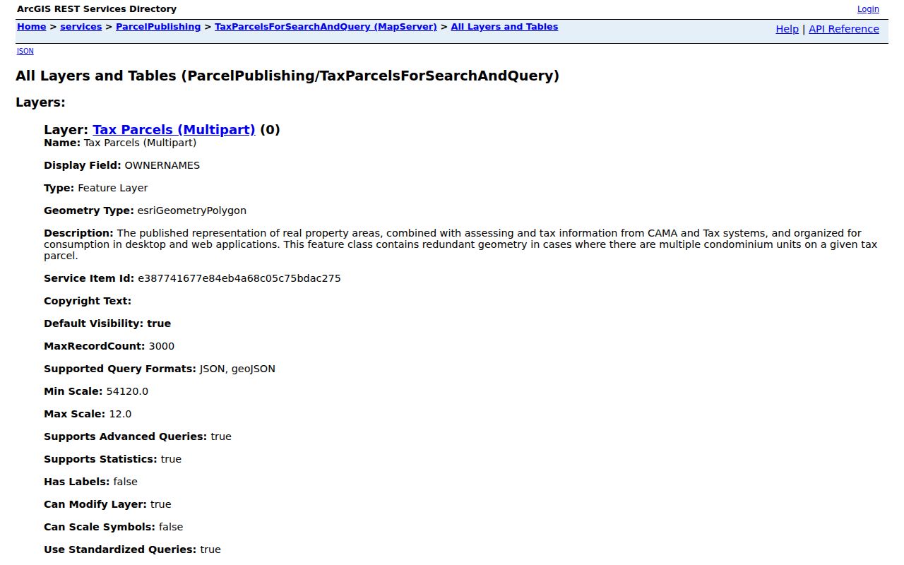
The list separates owner text, site and postal addresses, legal description, tax district, values, use, building facts, and update dates.
Layer Neenah Street Geography
Neenah's interactive map catalog adds aldermanic districts, polling places, parcels, Sanborn maps, aerial images, zoning, TIF areas, future land use, boundary agreements, and lead-service information. Each layer answers a different question. A ward is not a parcel, an assessment neighborhood is not a voluntary association, and a ZIP is not a city line.
Open the Neenah map catalog before viewing its captured menu.
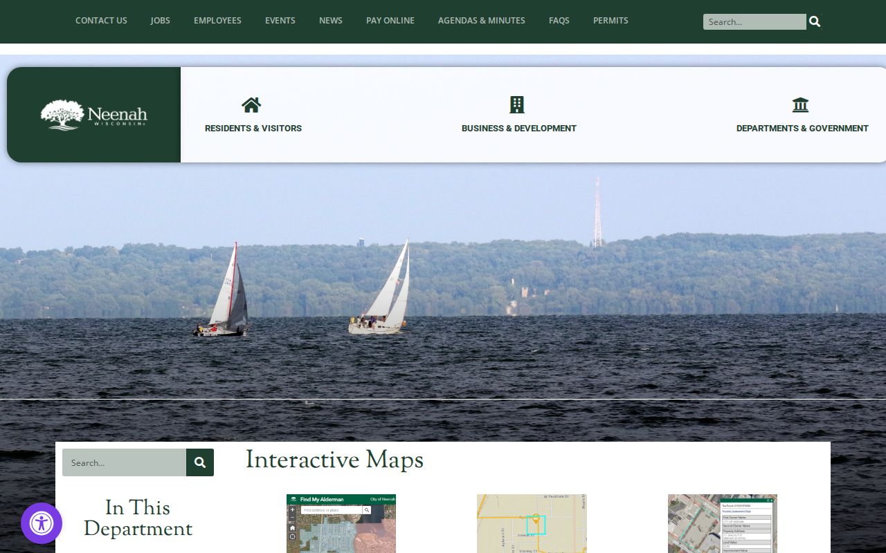
The range of choices helps test street context, but a person-level statement still needs a dated record that names the person.
Neenah's 2025 neighborhood group map uses labels such as Central Neenah, Doty Island, Woodside Green, and Residential Waterfront. Those are assessment areas. They do not prove that someone joined a neighborhood group.
Neenah Street Records Compared
Several official records accept an address or connect back to one. Their coverage and force differ. The city assessment is the best current ownership lead for a Neenah city parcel, while the deed is the recorded instrument. Permits record work. Historical directories supply a dated published association, and voter systems carry strict access and confidentiality rules.
| Address source | Responsible office | Street evidence | Ways to use it |
|---|---|---|---|
| Municipal assessment | City of Neenah | Owner, situs, mailing, tax key, sale and permit fields | Free web inquiry; assessor phone |
| Parcel map | Winnebago County GIS | Parcel geometry, owner, PIN, legal summary, linked profiles | Free viewer and county GIS help |
| Recorded deeds | Winnebago County Register of Deeds | Grantor, grantee, legal description, instrument and date | Tapestry, Laredo, public terminals, office help |
| Voter information | Wisconsin Elections Commission and clerks | Permitted voter geography and election fields | MyVote self-lookup or paid Badger Voters request |
| Building permits | Neenah Inspections and Public Works | Work at an address; applicant, owner, or contractor role | Online, in person, mail, email, or records request |
Keep the role label. A permit applicant may be a contractor. A tax owner may be a trust. A grantee acquired an interest but may not occupy the site. A published directory entry is only a snapshot from its edition year.
Carry Neenah Addresses to Deeds
The Winnebago County land-record search offers several access channels. Occasional remote users can use Tapestry, daily users can use Laredo, and visitors can search public terminals at the Register of Deeds. Most in-office land records reach back to 1850, while indexes reach back to 1935. Online and in-office coverage are not identical.
Search grantor and grantee names, then repeat with the legal description. A grantor transfers an interest; a grantee receives it. The county recommends quick party-name and advanced legal-description searches because indexes can contain errors. Tapestry charges $8.75 per search, plus $1 per image page and online sales tax, according to the researched county FAQ.
The Register of Deeds office at 112 Otter Avenue, Room 108, Oshkosh, is open weekdays from 8:00 a.m. to 4:30 p.m. Call 920-232-3390 before a historical visit to ask about terminal coverage and appointments.
Note: Record the document number, recording date, type, legal description, and book or page rather than relying on a name alone.
Neenah Permits by Address
A city property page may show permit number, purpose, amount, and issue date. Neenah Inspections routes permit and code questions through Community Development at 211 Walnut Street, Room 313, or 920-886-6130. The Public Works permit portal supports applications, plans, and permit-detail views. The city also accepts permit work in person, by mail, or email.
Permit activity helps date a change to a building. It cannot name a household unless the record expressly does so. Keep owner, applicant, and contractor in separate columns. If the public view lacks a needed record, send a narrow request through Neenah's open-records procedure. The city aims to answer or deny within five working days, or state when the record can be supplied.
Neenah Streets Cross Boundaries
Neenah has 132.75 miles of streets within about 9.6 square miles, according to city figures. Yet its mailing label is wider than the city. ZIP 54956 serves street-delivery addresses associated with Neenah and nearby places, while 54957 appears on post-office boxes. A county parcel may carry Neenah as its postal city while lying in the Town of Neenah or another jurisdiction.
Recent annexations near Liberty Avenue, Bayview Road, and Dixie Road also show why municipal identity needs a date. A postal label may stay the same while the tax district or city line changes. Check ordinances, parcel lineage, and map date before treating a jurisdiction as timeless.
Geography check. Keep postal city, ZIP, municipality, ward, assessment neighborhood, and parcel boundary as separate fields.
Neenah Streets in Old Directories
The Neenah Public Library's Dresser History Room holds Neenah and Menasha directories from selected years beginning in 1900 and continuing to current issues. Street indexes can work backward from a house number when a surname is unknown or misspelled. Since the run contains gaps, a missing listing is not proof that no one was there.
Use the full collection details on the Neenah city directory page, then compare the address with a census, newspaper, deed, or map. No official citywide crosswalk for every renamed or renumbered street was found. Preserve the old spelling and resolve one address through consecutive editions, ordinances, and Sanborn sheets.
Date Every Neenah Street Result
Current does not mean permanent. Neenah's 2026 assessor notice says field visits are occurring east and south of City Hall, so property facts and values may change after review. County GIS also maintains parcel lineage and update fields. A saved street directory result should show both the day it was searched and the effective or last-updated date printed by the source.
The same rule applies to old records. Cite the directory title, edition, page, city, street spelling, and database or shelf. For deeds, cite the instrument. For maps, save the sheet and year. This short source card prevents a live portal from being mistaken for a permanent record.
Limits of Neenah Street Records
A Neenah street directory cannot establish every person who lives behind a door. The assessor identifies a taxable ownership role, not all occupants. Deeds record transfers and interests. Permits identify participants in work. Directories can omit people, lag a move, or use a mailing address. MyVote is designed around self-confirmation, and Wisconsin protects confidential elector information.
Safe at Home supplies a substitute address to eligible people who fear for their safety. Never reverse-map, triangulate, or publish an actual location hidden by that program. The same restraint applies to full birth dates, identification numbers, account numbers, victim or witness addresses, and children's details.
Lawful use. Use Neenah address records for lawful personal research. Never use a street search to stalk, harass, threaten, or harm anyone.
When a result is uncertain, leave it uncertain. The strongest record states its role, source, and date without turning ownership or mailing data into a claim of current residence.